


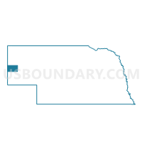
Highland Precinct, Scotts Bluff County, Nebraska
About
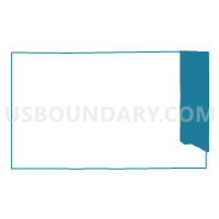
Outline

Summary
| Unique Area Identifier | 613901 |
| Name | Highland Precinct |
| County | Scotts Bluff County |
| State | Nebraska |
| Area (square miles) | 85.75 |
| Land Area (square miles) | 85.73 |
| Water Area (square miles) | 0.02 |
| % of Land Area | 99.97 |
| % of Water Area | 0.03 |
| Latitude of the Internal Point | 41.88056080 |
| Longtitude of the Internal Point | -103.41017730 |
Maps

Graphs
Select a template below for downloading or customizing gragh for Highland Precinct, Scotts Bluff County, Nebraska


Neighbors
Neighoring Voting District (by Name) Neighboring Voting District on the Map
- 11 Precinct, Box Butte County, NE
- Castle Rock A Precinct, Scotts Bluff County, NE
- Castle Rock B Precinct, Scotts Bluff County, NE
- Dewey-Tabor Precinct, Scotts Bluff County, NE
- Sheep Creek Precinct, Sioux County, NE
- West Bayard Precinct, Morrill County, NE
Top 10 Neighboring County Subdivision (by Population) Neighboring County Subdivision on the Map
- Eleven precinct, Box Butte County, NE (9,840)
- Dewey Tabor precinct, Scotts Bluff County, NE (1,776)
- West Bayard precinct, Morrill County, NE (852)
- Castle Rock precinct, Scotts Bluff County, NE (606)
- Sheep Creek precinct, Sioux County, NE (579)
- Highland precinct, Scotts Bluff County, NE (444)
Top 10 Neighboring Unified School District (by Population) Neighboring Unified School District on the Map
- Scottsbluff Public Schools, NE (19,048)
- Gering Public Schools, NE (11,327)
- Bayard Public Schools, NE (2,378)
- Hemingford Public Schools, NE (1,866)
- Minatare Public Schools, NE (930)
- Sioux County Public Schools, NE (870)
Top 10 Neighboring State Legislative District Upper Chamber (by Population) Neighboring State Legislative District Upper Chamber on the Map
- State Senate District 48, NE (33,594)
- State Senate District 47, NE (32,377)
- State Senate District 49, NE (31,705)
Top 10 Neighboring 111th Congressional District (by Population) Neighboring 111th Congressional District on the Map
Top 10 Neighboring Census Tract (by Population) Neighboring Census Tract on the Map
- Census Tract 9525, Morrill County, NE (5,042)
- Census Tract 9529, Scotts Bluff County, NE (2,781)
- Census Tract 9511, Box Butte County, NE (2,259)
- Census Tract 9532, Scotts Bluff County, NE (1,524)
- Census Tract 9501, Sioux County, NE (1,311)